7 Important Things You Don’t Know About GPS Tracking System
GPS is a very common word today. But even a generation back, no one even heard about GPS. In the span of just few years GPS has become ubiquitous in our life and every one of us is getting psychologically and physically dependent on GPS for our everyday travel and commute to places.
Many a times when we purchase a phone or a car, we ensure they have preinstalled GPS tracking systems. There are App Cabs companies, extremely popular of late, who uses similar GPS tracking systems. Even food delivery and all other logistics operations necessarily use GPS systems. But the fact remain, very few of us really know what GPS is and how it works.
- GPS isn’t unique – GPS is one of the several space-based radio navigation systems. The US Government Owns and Operates GPS. Like many modern technologies, GPS was born out of the military during the Cold War. Nuclear deterrence was in vogue that time, and precise location of submarines and fighter jets was important. Although the Cold War had ended 4 years prior with the collapse of the Soviet Union, GPS became fully operational in 1995. At first, the highest quality signal was reserved for military use but in 2000 GPS was made freely available to the public as a national resource.
To achieve global coverage for GPS, 24 satellites are required. The first of the 24 was launched in 1989 and the 24th was launched in 1994. GPS satellites only last about 10 years, and often need servicing during their lifetime, which is why there are currently 32 GPS satellites in orbit. The extra satellites fill in the gaps when the core 24 satellites need to be serviced or decommissioned, so that coverage is maintained.
Other countries have set up their own satellite-based navigation systems, including Russia, China, India and the European Union, so that the reliance on the US based GPS system is minimized.
-
- Russia was developing its system, GLONASS, at the same time as GPS and it became fully operational around the middle of 2000, though the accuracy of GPS remained higher than GLONASS.
- European Union developed Galileo, which is expected to reach global coverage by 2020 and will potentially be even more accurate than GPS and would be the first publicly owned Global Navigation Satellite System, GNSS.
- China’s GNSS is named as Beidou, and is expected to be complete by 2020, which would potentially cover the whole world and would compare with the accuracy provided by GPS.
- India also has invested heavily to develop its own GNSS and named it as IRNSS (Indian Regional Navigation Satellite System). The coverage of IRNSS is around the subcontinent of India, including its neighboring countries.
In short, the GPS war has begun. That’s a massive change for the United States, which for decades has had a practical monopoly on determining the location of objects through its Global Positioning System (GPS). Owning GPS has a number of advantages, but the first and most important is that global military and commercial users depend on this service of the U.S. government, putting location targeting ultimately at the mercy of the Pentagon. The development of the technology and the deployment of positioning satellites also provide a spillover advantage for the space industry and Location Business Services.
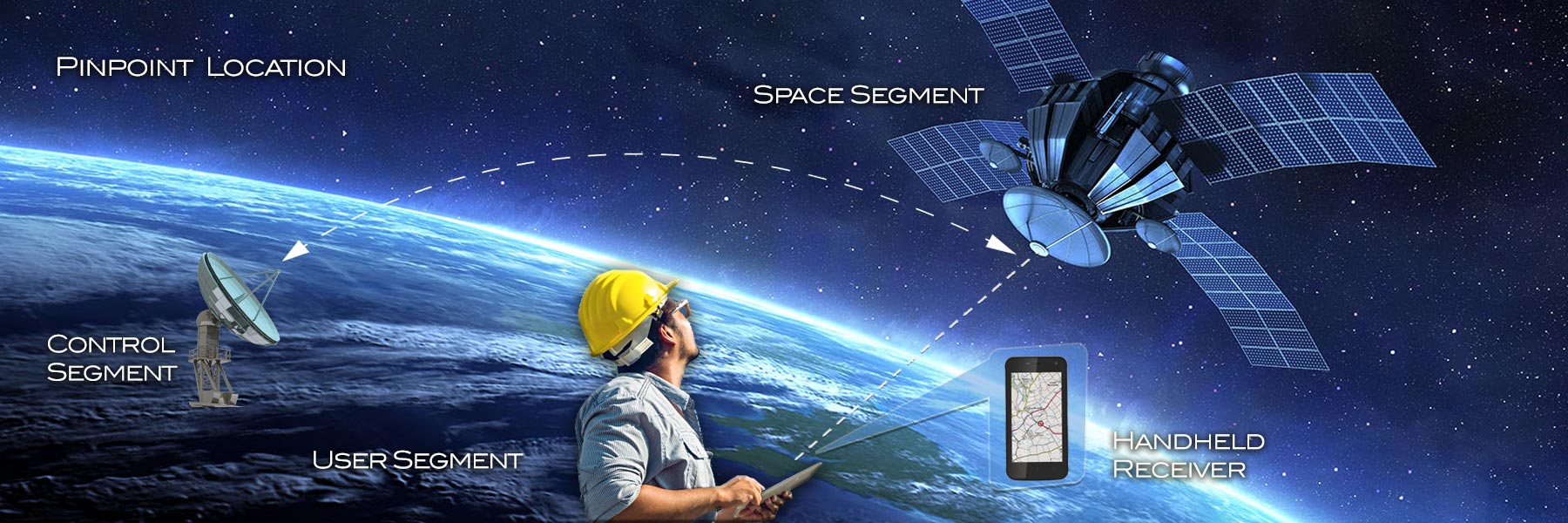
- How GPS works – The constellation of satellites above in each of the systems we mentioned earlier knows its exact position. There are GPS satellite receivers in the ground, which connects to these satellites and receives the data from them. This receiver in turn consumes these data from different satellites and calculates its exact location.
- What information does a GPS provide – A GPS would provide you exact latitude, longitude, altitude, direction of movement if any, and the precise satellite time.
- Accuracy of GPS technology – Accuracy of information from your GPS is dependent on a number of factors, such as satellite geometry, signal blockage, atmospheric conditions, and the quality and design of the receivers it uses to communicate the information. It can range from 30/50 meters to one millimeter.
At the bare minimum, if 4 satellites are within line-of-sight of any location on Earth at any time, you can ideally get a location from the GPS. More the number of satellites connected, better the satellite geometry and atmospheric conditions, the more precise the accuracy of GPS is.
Many countries have developed GPS augmentation systems, which improves the accuracy of the location in those countries through corrections. India has GAGAN (GPS Aided Geo Augmented Navigation) developed by ISRO. Japan has Quasi-Zenith Satellite System (QZSS).
When your GPS receiver uses these augmentation systems the accuracy improves substantially. Like in India the accuracy is higher when your GPS is GAGAN enabled.
Many a times the GPS satellite receivers use more than one system, thereby increasing the number of connected satellites. These concurrent multi-GNSS GPS receivers provide higher precision.
- GPS works even when you have no cellular signals – GPS system is based on satellite communications, which is always available, all throughout the Earth. So even if you don’t have a cellular network, your GPS should work.
Most of the times, your mobile phone would come with A-GPS (Assisted GPS), where the mobile phone uses cellular network in addition to GPS satellites to provide you location accuracy.
- GPS doesn’t work indoors – Since GPS is a system based on satellites in the line-of-sight, while you are indoors, the GPS ceases to work. Your mobile phones are equipped with A-GPS, you would still get location indoors using the cellular networks.
- The future – GPS is a relatively recent technology. We have for centuries used maps and other ways to navigate to places. Taxi drivers in most of the large cities know most of the locations, routes and navigation alternatives by heart. Researchers don’t know yet the extent of the impact on the human brain with the advent of GPS, but there is some evidence that an over reliance on GPS may also be questionable for our brains, as parts of the brain that are used to navigate and plan routes are no more active when directions are fed to us. Prolonged nonuse of these areas like hippocampus (memory and navigation) and pre-frontal cortex (decision-making and planning) of the brain can probably lead to issues, which would need more studies.
The precise location and timing ability of GPS is a critical enabler of many IoT (Internet of Things) applications. This GPS system would become the backbone for many emerging areas starting from precision agriculture, to automated vehicles, to fleet tracking, to smart mining, Smart Grid systems, Smart City implementation and many more.